- Satellite SAR Data processing
- SAR Data Application (Forest Mapping, Agriculture Mapping, Urban Feature Mapping, Ship Detection)
- DATA fusion
- Snow-Avalanche Mapping
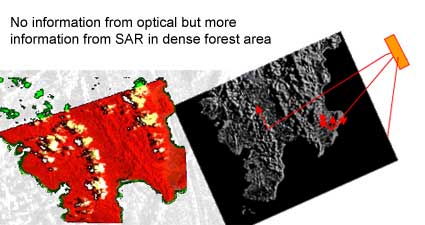
We do integration of SAR data with optical images and GIS- related information. Practical applications are in areas of vegetation mapping, crop monitoring, biomass estimation, monitoring of flooded areas, of soil moisture estimation, oil spill etc.
Radar Imagery is an increasingly important source of information for many applications because of its characteristics fine resolution and side-looking nature.
Airborne as well as satellite SAR (X, C, L hand) data have been effectively used to bring out earth features (natural as well as man-made)
SAR team at SAKURA-GSR works on development of interpretation keys for target from SAR images, development of innovative research ideas for forest mapping, oceanography and Defense related work.
SAKURA-GSR is aiming to develop several research software using SAR data Mapping applications: Geological Landform, structure, revealing geology of dense forest areas, forest, urban morphology, change-detection studies, ship-detection, agriculture studies etc.
SAKURA GSR is capable of developing comprehensive interpretation keys for urban, agriculture, forest, water bodies and open land. Keys and geometric analysis of some manmade features are possible


